Strictly Copyright June 2015 – To be reproduced only with the permission of Dorothy M. Felton.
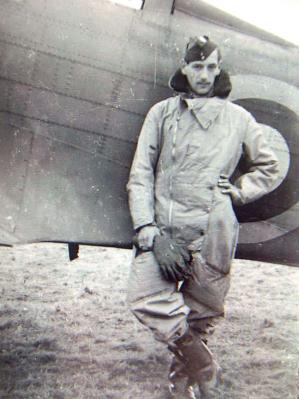
Philip Felton served with 21 and 82 Squadrons having joined the RAF Volunteer Reserve in 1938 aged 17. At the outbreak of War, he was sent to Hastings for training and began his career as an Observer in the Air Force
At the end of the war Philip went to University in Southampton and studied Electrical Engineering and then joined the Southampton City Police Force.
In a lecture to the King Alfred Probus Club in Winchester Philip related some of his story . . .
Good afternoon Gentlemen,
I would like to start by reading you a poem, written by a Canadian Spitfire Pilot who sadly was killed soon after. It was his idea of aerial navigation.
Oh! I have slipped the surly bonds of Earth
And danced the skies on laughter-silvered wings;
Sunward I’ve climbed, and joined the tumbling mirth
Of sun-split clouds, and done a hundred things
You have not dreamed of, wheeled and soared and swung
High in the sunlit silence.
Hov’ring there,
I’ve chased the shouting wind along, and flung
My eager craft through footless hails of air . . .
Up, up the long, delirious, burning blue
I’ve topped the wind-swept heights with easy grace
Where never lark, or ever eagle flew,
And, while with silent lifting mind I’ve trod
The high untrespassed sanctity of space,
Put out my hand, and touched the face of God.
High Flight by John Gillespie Magee, Jr. 9 June 1922 – 11 December 1941
First let me say that I am not and was not an expert in aerial navigation. I was a wartime product of a 13-week course, in 1940. We learnt our basic skills in Avro Ansons, mainly over the Midlands and Wales. I remember being hopelessly lost over Wales and asking the Pilot to follow a railway line in the hope of reading the next station. But unfortunately all the stations names had been removed.
I learned that the world was an oblate spheroid which made navigation very difficult at the Poles but fortunately, I didn’t have to get anywhere near the Poles. A clever chap named Kreimer, in the 16th century, had discovered a way of displaying the surface of the Planet on a flat surface for the use of sailors. His invention was called Mercators Projection and is the basis for all maps and charts even today. Lines of latitude girdle the earth parallel to the Equator and lines of longitude run from Pole to Pole like the segments of an orange.
The lines running north to south and east to west on a chart are known as the Grid system and one based on true North – i.e. Pole to Pole. All very neat and tidy but now a few complications creep in. Charts are measured in nautical miles and maps in statute miles, there being 1.15 statute miles to a nautical mile. Not much you say, but over a distance, say 1000 miles, the difference is 150 miles.
Another complication is that the magnetic pole as measured by a compass is not at the North Pole, but some way off in Baffin Land, North of Canada. The difference between true north which is the basis of all maps and charts and magnetic north indicated by a compass, is called the variation. This varies wherever you are in the world. This variation is marked on all maps and charts in degrees. For Europe it is about 14 degrees.
Another complication is that a compass which is of course the main instrument of navigation being situated in an aeroplane, which is made of metal, including the engines, which affect the true reading. This is called the deviation and also has to be taken into consideration when laying a course to steer.
One of my jobs as a navigator was to ’swing the compass’. This entailed placing the aircraft on the cardinal compass points painted on the ground and getting the aircraft rotated to these cardinal points and adjusting the compass reading by manipulating little magnets fixed under the compass. This still left a small error, which was called the deviation and had to be taken into consideration again when laying a course.
However, the main problem of aerial navigation is that the moment you leave the ground in an aeroplane, you are in a moving medium and you are part of it, so you must know the speed and direction of this movement in order to fly a course with any accuracy. We call this movement, the wind and a navigator has to make every effort to discover its speed and direction.
I’d just like to remind you at this point of the conditions that applied in wartime 1940. Very little weather information was available; no weather ships were in operation. There was no international co-operation weather wise and no satellites or computer.
The local surface wind speed and direction was known as also the fact that as the plane leaves the ground and gains heights the wind direction will veer and the speed will increase. This is known to a certain extent by observing the behaviour of a balloon. But as you may know from seeing weather maps on the TV, there is a great variation of wind-speed and direction over distances.
Generally there is an on shore wind in the morning (As the air on high ground rises with the warmth of the morning sun), similarly, in the evening there is an off shore wind (As the air on high ground cools and falls).
Every RAF Station had a met-officer who did his best to give the navigator the weather he could expect to meet along his flight path. This information he gained by observation and by debriefing returning aircrews.
As a navigator I was to make weather observations along my route such as temperature, pressure and cloud formation. The met-officer used any scrap of information he could obtain to make weather charts.
The simplest way to ascertain the wind speed and direction over land is by map reading. The compass course is known and the airspeed is known so we can draw a line on the map indicating our course and speed over a distance. Then, having ascertained our actual track over the ground by map reading and the time taken to cover the ground between two points, we can work out our ground speed. So starting from the same point, we draw a line indicating our track. Thus we have two sides of a triangle and closing the open end gives us the wind speed and direction.
This was known as Vectoring. ALL CLEVER STUFF !
Unfortunately, most of our actual operations were over the sea – so map reading was OUT. Our main instrument of navigation for the observer in the nose of a Blenheim, was a compass and bombsite known as the ‘course setting bomb site’… It had a glass top and a china graft pencil to draw vectors.
Extending from this compass was a length of parallel wires graduated in distances for different heights. These wires could be rotated to line up with the direction of travel. There was a theory that one can still ascertain the drift which is the angle the aircraft moves away from its compass course by putting ones eyes out of focus and staring at the sea through the bomb site wires! Lining them up with the streaks of foam on the surface of the sea. It may work in some sea conditions but I never found it so.
So we had to rely upon the Met Officers forecast of wind speed and direction and we navigated by what was known as dead reckoning and used this information to make out our flight plan, our course to steer and the estimated time of our arrival at the target. Of course making a landfall by recognising a coastal configuration helped.
Most of our targets were enemy shipping but occasionally we were sent into enemy territory, and as this enemy territory was distant over some hundreds miles of sea, a landfall, some distance from the target, gave the enemy advance warning of your approach and heavy losses of our gallant crews resulted.
In my Squadron some months before I joined it, twelve aircraft were sent to bomb a German Airfield in Aalbourg in Denmark. Unfortunately the navigation was imperfect and they made a landfall twenty miles south of the target. Apart from one aircraft, which turned back through a fuel fault, the remaining were all shot down.
So you see, correct navigation was absolutely essential but almost impossible to obtain. Between the 24th March and the 31 October 1941, 160 Blenheims with 480 aircrew were lost in operations against the enemy shipping and coastal areas. This did not include the crippling losses suffered by the Squadrons who were detached from the group to operate from Malta. Flights of aircraft were sent out to Malta every few weeks to replenish those lost.
Now comes the part where I had to put all these theories into practice. This will be a little of a line shoot but really it is a tribute to the 55,000 aircrew who did not survive their practical experience.
When I finished my basic training as an Observer, which included, besides navigation, bombing and gunnery, aerial photography, Morse code signalling and meteorological observations. I was posted to an operational training unit as a qualified Observer, proudly wearing the Observers Brevet.
My first duty was to meet with newly qualified Pilots and newly qualified Wireless Operator Gunners because I was to fly in the Blenheim Medium Bomber with a crew of three. The Blenheim was twin-engined with a bomb load of 1,000 pounds.
We all met in the same room and socialised and were expected to choose our own crew. In my case I had to choose a Pilot and a Wireless Operator Airgunner and they had to choose me. We were all Sergeants and miraculously, within a few hours we had made our choices. The vast majority of aircrew in Bomber Command were NCOs.
We then commenced a very concentrated course of flying where we were melded together as a team. One of the last exercises was for the Pilot to land the plane at night time although we were to be on daylight operations. This was called dusk to dark, circuits and bumps. I was not required, but the airgunner was as German fighters occasionally joined in the circuits and shot down our planes.
Unfortunately, my chosen crew with whom I had worked so hard crashed and were killed, so I was a spare Observer again. However, a Blenheim Crew who had lost their Observer quickly snapped me up and I flew with them to their Squadron – 21 Squadron at Watton in Norfolk. My Pilot was a Flying Officer.
I was with an Operational Squadron at last, but with a strange crew. I was initiated into the Squadron by being made to stand on a table in the Mess, holding a pint of beer whilst they sang a song which ended with the words “Down, Down Down”…and in that time they were singing “Down, Down, Down”, the pint of beer had to be downed. Of course after several unsuccessful attempts and being completely soused in beer, I was admitted to the Squadron.
Two days later, my crew and I were sent on my first Operation against the enemy. It was a daylight attack on an oil refinery and power station at a place called Gosnay, near Bethune in Northern France.
We were eleven aircraft, in Vics of three, led by a Wing Commander, so although the Wing Commanders Observer did the navigation, I had of course to be aware of all the navigational matters. On arrival over the target, I aimed and dropped our four – 250lb bombs and turned for home. Messersmichts 109’s attacked us but we were successful in returning to the Squadron, because we had on this rare occasion fighter escorts of 200 fighters.
You may ask, why 200 fighters??? We were in fact acting as a bait to draw up the enemy fighters – this was in addition to bombing legitimate targets.
A few days later, nine aircraft of the squadron, led by a Squadron Leader set off to bomb a seaplane base on the island of Borkum – one of the Frissan Islands. These seaplanes had been laying mines in our sea approaches – this target was a 500 mile round trip across the North Sea, taking four hours. We were
very anxious to make an accurate landfall in order to have the advantage of surprise. However, when we were still fifty miles from the target, we encountered a small German Convoy. We aborted our attack on Borkum and attacked the Convoy because it would have radioed our approach and alerted the defences.
On this trip I had a huge camera F24 oblique hand held with which I took photographs of the ships. This was for intelligence as to the movement of shipping off the enemy coast.
One of our aircraft was damaged by anti aircraft fire and could only fly at a reduced speed. We escorted it back to England.
A few days later came my first trip where I was responsible for the navigation!! We flew up to Lossiemouth prior to attacking enemy occupied Norway. However, before we received any orders for an attack, we were ordered to return to Watton with a view to being sent out to North Africa. We were transferred to 82 Squadron and were given a brand new Blenheim, which was specially adapted for use in the desert. That’s where I ‘swung the compass’!
We were sent to Portreath in Cornwall, being our nearest point to our first destination on our way out to Africa – Gibraltar. This was a 1000 miles (our extreme range), across the Bay of Biscay. We were on our own with orders to fly as low as possible across the water to avoid detection from bases in Spain, although neutral, were hand in glove with the enemy. For the same reason, we were ordered to keep radio silence.
I laid off my course and was very worried about arriving on the North coast of Africa so I constantly checked any drift I could observe from the surface of the sea and just to be sure, I asked the Pilot to alter course a few degrees to the East !!!! – and in the event, we eventually arrived on the coast of Spain some fifty miles North of Gibraltar.
We followed the coast around until Gibraltar came in sight. Now this was were I had to signal Gibraltar that we were a friendly aircraft. For this I had an Aldis Lamp and I sent the letters of the day in mores code with the lamp. The only problem was, I didn’t know where the signal station was on the Rock and as the Aldis signal, which is focused by a telescope, can only be read over a certain radius. So I sent my signal to the top of the Rock – halfway down and at the bottom. I must have got it right because we were allowed to land. Very relieved after an eight-hour flight.
Our next port of call was to be Malta – another 1000 miles distant….. which was our extreme range. In fact, we had to wait until we were given a wind, either following or zero to enable us to reach Malta. After a few days, we were told the wind was in our favour and we set off again with orders to fly low across the sea, out of sight of land, and to keep radio silence. Again, we were on our own.
Now as you probably know, the Mediterranean is subject to many changes in the wind. The Mistral flowing from the South of France, The Sirocco flowing north from Africa and the Levant flowing in a Westerly direction in general. As you can imagine, my anxiety to make a successful landfall was very great. I stared at the sea, which was very calm and could get no inkling of any drift. Consequently, when it came to my estimated time of arrival at Malta, with our fuel very low, there was no sign of this Island.
Malta is only 17 miles long and 5 miles wide. It is 60 miles south of Sicily and 18 miles from the North African Coast. This is where my training came to the fore. I commenced a square search.
This means each side of the square is longer by twice the visibility, so you can see, the square grows larger and larger. After two legs of this square search and no sign of Malta, our fuel position becoming desperate, we decided to break radio silence and ask Malta for a bearing. This they gave us and we just made it to Luqa, on Malta, before our fuel ran out.
Very soon after we arrived, the Air Officer Commanding Malta told we that we were not going on to Alexandria but were to operate from Malta.
Malta at this time was under siege, being bombed heavily every day. Food was scarce and the bombs needed for the anti shipping role we were to assume, were only general purposes and we needed semi armour piercing.
We were to attack the ship convoys supplying Rommel’s Africa Corps.
The day after we arrived, we were sent to bomb a ship that had been found off the coast of Sfax in Tunisia. My Pilot had been promoted to Acting Squadron Leader so I was now Navigator for the Squadron.
We found the ship and bombed it and safely returned to Malta.
Two days later, the reconnaissance plane had found a large convoy off the coast of the Island of Pantelaria. We led a Squadron of six aircraft to attack the convoy, which we found was escorted by two destroyers.
As we neared the convoy we were hit by anti aircraft fire but carried on and bombed a ship when we were hit again and we crashed into the sea on the far side of the convoy.
My talk was to be ‘NAVIGATION . . . but as I mentioned earlier, I also wanted pay respect to the Blenheim Air Crews.
The majority of whom did not survive.
On the 30th August 1941…Winston Churchill said…
“The devotion and gallantry of the attacks of the Blenheim Squadrons are beyond praise. The Charge of the Light Brigade is eclipsed in brightness by these, almost daily, deeds of Fame.
A Flight Sergeant named Fred Doody was killed in 1939 of Heligoland, recently, the effects of his widow were cleared away and a poem was found believed written by her husband, Fred.
KISS IN THE NIGHT….
I sent you a kiss in the night, did it reach you my darling.
Did it reach you and rest on your lips.
In the stillness apart did we meet in the spell of that kiss?
Did I hold you my darling for just one beat of your heart?
Did I tell you to dream of the light and not of the shadows?
To dream of the sunshine and song of that golden tomorrow
My heart has planned for you.
I sent you a kiss in the night, did it reach you my darling.
When the wind sang a song to the leaves,
And the stars were so bright.
Did you stir in your sleep, did you smile.
Did I bring you, my darling a moment of bliss?
When I sent you that kiss in the night.
Philip Felton finished up a POW here are some extracts from his diary as liberation came . . .
DIARY OF LIBERATION FROM STALAG IV B Philip L Felton
Friday 13 April 1945
Camp Commandant; Captain Koenig handed over camp administration to Lieutenant Jessop.
Friday 20 April 1945
Captain Koenig offers to evacuate camp to Western side of river Elbe. All nationalities refuse except the Poles who move at midnight.
Monday 23 April 1945
04 am. Russian Cossacks arrive at camp. Germans had left at midnight. Wire down. Russian K.G’s march eastwards.
23 April until 05 May 1945
Awaiting order to move. Various visits by British and American Officers. Few cigarettes and sweets. Some newspapers (27 April 1945). Promises of flying home from local aerodromes or landing strips. (Wrote home but disallowed by Russians)
Sunday 06 May 1945
Order to move. Our turn 2.30pm. Marched off. Destination unknown. En route to Riesa, distance 20km. Got lift at Strella for about 6 or 7 km. Arrived Reesa, billeted in Hotel/flats. 13 to a room.
Tuesday 08 May 1945
Registration today prior to moving further west. War in Europe finished. Hope to move tomorrow.
Wednesday 09 May 1945
No move materialized.
Interim: several dates for move officially given by Russian General and Anglo/American staff officers.
Monday 21 May 1945 (Whitsunday)
No move
Wednesday 23 May 1945
Left camp at 1800; marched into Riesa and boarded American Lorries. Left at 1900 with band playing and official farewell party of Russian officers and Brigadier Venables. By-passed Leipzig and arrived Halle aerodrome at 2300. Group No. 128D. Bags of grub, marvellous treatment.
Friday 25 May 1945
2,500 left today (100 aircraft) DC 47 (cows!) Probably tomorrow for us. Wrote home through American Red Cross.
Saturday 26 May 1945
Fine sunny day, plenty of aircraft arriving.
Monday 28 May 1945
Beautiful day! Airborne 1545, Keessel 16.30, crossed Rhine 17.15, arrived Brussels 19.00. Left Brussels 1930 (for Blighty!). Over Dunkirk 20.00, Blighty up!, White Cliffs, possibly Deal. Crossed coast 20.20 ½. YIPEE!
